President Trump won’t let it go.
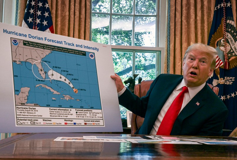
After touting a seemingly doctored map on Wednesday of Hurricane Dorian’s forecast path that erroneously showed the storm possibly headed for Alabama, the President dug in his heels on Thursday.
He began his morning tweeting:
….Instead it turned North and went up the coast, where it continues now. In the one model through Florida, the Great State of Alabama would have been hit or grazed. In the path it took, no. Read my FULL FEMA statement. What I said was accurate! All Fake News in order to demean!
— Donald J. Trump (@realDonaldTrump) September 5, 2019
Later Thursday morning, the President tweeted again:
Alabama was going to be hit or grazed, and then Hurricane Dorian took a different path (up along the East Coast). The Fake News knows this very well. That’s why they’re the Fake News!
— Donald J. Trump (@realDonaldTrump) September 5, 2019
Trump’s son, Eric Trump, backed his father up, making an argument about media bias:
This pettiness from the @washingtonpost is exactly why the public hates the media. This is a basic graphic from the NHC – I don’t think it’s beyond comprehension that Alabama was in the path had the storm not gone North. Stop the BS. The Washington Post is a joke. #Alabama https://t.co/hdsOohU5WI pic.twitter.com/SMVNVC11E4
— Eric Trump (@EricTrump) September 5, 2019
The National Hurricane Center never issued warnings for Alabama or any part of the Gulf Coast, but starting on Sunday Trump insisted, despite all evidence to the contrary, that the state was at risk.
The doctored map Trump displayed in the Oval Office on Wednesday was a National Hurricane Center advisory from Thursday, Aug. 29. Since then, the storm has tracked up the southeastern U.S. coast.
As Phil Klotzbach, a research scientist in the Department of Atmospheric Science at Colorado State University, told TPM via email Wednesday: “President Trump’s forecast map that he showed was from a few days ago, and someone from the White House must have drawn a bubble on it to include Alabama. Alabama was never in the forecast cone issued by the National Hurricane Center.”
To further bolster his dubious claim, Trump on Thursday also retweeted a map of various forecast models for the storm, which shows Dorian possibly heading in lots of different directions.
This was the originally projected path of the Hurricane in its early stages. As you can see, almost all models predicted it to go through Florida also hitting Georgia and Alabama. I accept the Fake News apologies! pic.twitter.com/0uCT0Qvyo6
— Donald J. Trump (@realDonaldTrump) September 4, 2019
CNN meteorologist Allison Chinchar explained on air Thursday that the map is intended for use by professionals because it’s difficult to interpret.
“This is the map that the President tweeted,” she said. “I would like to note the official National Hurricane Center track is within this. It’s the red line with the red circles there that you can see. But again it’s hard to even see that amongst all of these countless lines that are in here, which is why they have the disclaimer at the bottom. National hurricane advisories supersede this product. If anything on this graphic causes confusion, ignore the entire product. That’s why the National Hurricane Center takes a look at those. They try to condense that many lines into the ones that they tend to think are more reasonable. They will throw out the erroneous ones. They take into account the ones that have higher resolution.”
CNN meteorologist explains the spaghetti plot hurricane map Trump tweeted out pic.twitter.com/szEl6giakD
— TPM Livewire (@TPMLiveWire) September 5, 2019
Later on Thursday, the White House released a statement from Rear Adm. Peter Brown, the President’s homeland security and counterterrorism adviser, who said he was the one who briefed Trump on the storm’s potential impact on Alabama.


