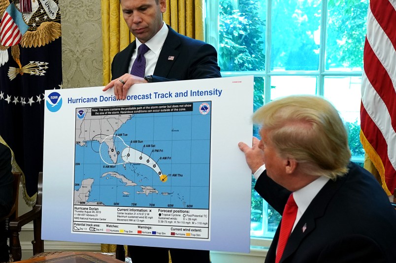
When President Donald Trump displayed a map of Hurricane Dorian’s projected forecast to news cameras in early September last year, the graphic included an odd bubble, seemingly drawn on to the end of the forecast cone — a piece of DIY meteorology which, inaccurately, showed Alabama at serious risk of Hurricane-force winds.
Adding insult to injury, an unsigned public affairs statement from the National Oceanic and Atmospheric Administration, two days later, criticized a local forecaster who told the truth about the risk facing Alabama.
But inside the NOAA, the White House hurricane doodle led to confusion, panic and anger at the politicization of science, new documents show.
“For an agency founded upon and recognized for determining scientific truths, trusted by the public, and responsible in law to put forward important science information, I find it unconscionable that an anonymous voice inside of NOAA would be found to castigate a dutiful, correct, and loyal NWS Forecaster who spoke the truth,” then-NOAA Assistant Administrator Craig McLean wrote in an email on Sept. 7, in the proverbial eye of the media storm.
BuzzFeed News on Friday received the fruits of a public records requests for communications within the NOAA about the White House’s defaced Dorian map — which one unnamed official said was Trump’s own handiwork, doodled amid his (false) declarations that Alabama was at serious risk from the storm.
“What concerns me most is that this Administration is eroding the public trust in NOAA for an apparent political recovery from an ill timed and imprecise comment from the President,” McLean added in his email, which was included in the records BuzzFeed published Friday.
The records show that NOAA officials panicked at how to respond to the White House misrepresentation.
One agency spokesperson, sending an email up the chain after a reporter asked about Trump’s marked up map, wrote simply: “HELP!!!”
In another email on Sept. 4, Corey Peiper, with the National Weather Service communications staff, wrote to the Susan Buchanan, the NWS director of public affairs, “The chart shown in the briefing is old and doctored to extend the cone into Alabama.”
Was he sure it was doctored? Buchanan responded.
“Yes,” Peiper wrote.
Read BuzzFeed’s report here.


