Accurate digital mapmaking has never been more important, as Apple’s recent fiasco with its new, glitchy and inconsistent Apple Maps app has shown.
But aside from consumer digital mapping industry leaders Google Maps, Nokia Maps, Microsoft Bing Maps (which also uses some Nokia data) and OpenStreetMap, another website has a vast trove of geolocation data extending around the globe: Wikipedia, the free crowdsourced encyclopedia launched in January 2001, maintains latitude and longitude coordinates for nearly 800,000 different articles in its English version alone.
The coordinates correspond to the relevant locations, places and landmarks described in the articles. Altogether, Wikipedia has coordinates of 1.2 million different locations at the time of this post’s publication, according to the official Wikipedia toolserver (scroll down to see total coordinate and article numbers).
To be clear, Wikipedia doesn’t actually maintain its own separate interactive digital world map website, at least not yet.
“There isn’t currently a Wikimedia Foundation interactive mapping project, but within the open-source community there are very strong open-mapping services already in their maturity,” a spokesperson for the nonprofit Wikimedia Foundation, which helps fund and organize the hardware and infrastructure necessary for Wikipedia and the associated Wiki-projects, told TPM in a statement.
But even though Wikipedia isn’t building its own map service yet, it’s got a bunch of map-service like features already built-in, which editors are improving all the time.
Already users can click on the coordinates found in the upper-right hand corner of a Wikipedia article, which gives them the opportunity to open the location in Google Maps, OpenStreetMap or numerous other digital mapping services available online.
Here’s a screenshot showing where to find the coordinates in a particular article:

Wikipedia also offers on many geo-tagged articles a pop-out view of an interactive globe called the “WikiMiniAtlas,” which is powered by OpenStreetMap data. Wikipedia articles that support this feature have a tiny globe icon in the upper right hand corner, which opens the atlas when clicked.

As the WikiMiniAtlas entry reads: “The map contains links to all other geocoded articles in Wikipedia and can be magnified down to approximate 100m (meter) resolution worldwide. While it looks similar to Google Maps it is our own software and free data.”
The WikiMiniAtlas also contains geolocation data and interactive views of other planets and planetary bodies, namely the Moon, Mars, Venus, Mercury, and Saturn’s moon Titan.
Here’s a screenshot of the WikiMiniAtlas view of a location on Venus:

The Wikimedia Foundation was careful to point out to TPM that all of the views in WikiMiniAtlas, and Wikipedia’s collection of geographic interplanetary coordinates in general, are maintained and upgraded by some of Wikipedia’s active volunteer editors around the globe, or Wikipedians, of which there are currently 131,933 (based on account activity in the last 30 days).
“We don’t get directly involved in editorial practices or standards on Wikipedia,” a Wikimedia Foundation spokesperson told TPM in a statement, further adding that all of the features seen in the WikiMiniAtlas “were borne of the volunteer editor community.”
And while Wikipedia’s map features may for now pale in comparison to those found in Google Maps, the website’s editors are continually making improvements, the latest including 3D wireframes of buildings that adjust perspective as a user navigates around the map view in the WikiMiniAtlas, a feature that began to be implemented in August 2012.

Since 2007, the WikiMiniAtlas has also supported a “photo map” view of geotagged images that bears a striking resemblance to similar photo maps employed by Apple and Instagram.

Also, it’s worth noting that Google Maps has its own Wikipedia article view built in (located under the “Traffic” drop down menu), although it can be overwhelming at times, especially in densely populated areas, as the following screenshot indicates:

Of course, some members of the broader Wikimedia project are more interested in the mapping capabilities afforded by the encyclopedia’s massive cache of coordinates than others.
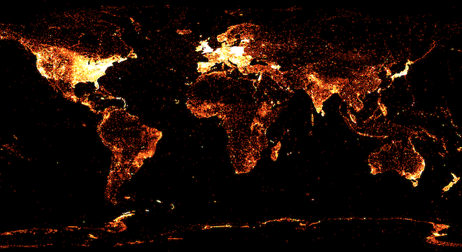
In January of this year, Denny VrandeÄiÄ, a German software researcher now employed at Wikimedia’s Wikidata project, created his own world map of all the geo-tagged articles in just a few days of work, with different views corresponding to 12 of Wikipedia’s 281 supported languages.
The views show a startling disparity between the geo-data, and articles in general, across languages. Here’s a screenshot comparison between the English Wikipedia map and the Italian Wikipedia map:


“In order to visualize the lack of coverage in many languages, I decided to create maps of all geotagged articles in a selected number of languages,” VrandeÄiÄ told TPM via email. “The Wikipedia Map was the result of that work.”
Fair warning though: VrandeÄiÄ’s map, which is best viewed in the Google Chrome browser, is so data-rich that it is extremely slow to load however, and may cause some browsers to crash. Access it here.
VrandeÄiÄ’s map was posted to the data-visualization website Visual.ly where it quickly became one of the most popular experiments on the site, and was in October applaued by Popular Science.
VrandeÄiÄ told TPM that in his own opinion, he thought that Wikipedia should eventually move to offer its own digital map.
“Yes, in the long run it [Wikipedia] should, but not in competition with Open Street Maps, but complementary and in cooperation to it,” VrandeÄiÄ wrote. He added:
“But I don’t think that goal should be a high priority. Making it easier to edit, increasing the appeal of the [Wikipedia] project as a whole, further improving the outstanding internationalization, and having more structured data available in general should, and is, a higher priority than its own online map. But one of the greatest advantages is that these priorities do not apply to third parties, i.e. us as the community. So if someone wants to create such a service, the data is there!”
VrandeÄiÄ said that he planned to make updates to his own Wikipedia map in the coming days.


