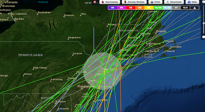
If you live in a coastal region, and ever wanted to know how many hurricanes struck your hometown in the past 150 years, this web application is for you.
The new Historical Hurricane Tracks app from the National Oceanic and Atmospheric Administration (NOAA) combines a slick user interface with a treasure trove of tropical cyclone data from around the globe, as NOAA explained to TPM on Tuesday.
“We feel that it’s important for people to understand where hurricanes have hit in the past, to give an idea of where they might touch down in the future,” said NOAA communications director Donna McCaskill in a phone interview with TPM on Tuesday.
The Web app, which NOAA describes as an “interactive map,” allows users to plug-in a specific zip code or city name from nearly any coastal region across the world and see all of the hurricanes and other lesser tropical storms that have roared through in last century and a half.
The hurricane paths are represented by color-coded lines that indicate the intensity of each storm (category one, the weakest, is colored yellow, while five, the strongest, is purple). Users can also hover their cursors over the hurricane lines to pull up the corresponding name of the storm (if named) and the precise date it hit. Clicking on a particular storm path will also bring up NOAA charts showing the storm’s maximum windspeed and pressure at various points throughout its journey.
Further, users can even share the results of any particular storm or storms using handy links that NOAA provides. Check one out here.
The app is actually an updated version of a tool that NOAA first launched 10 years ago on the first day of the Atlantic hurricane season: June 1, 2002. But the app was limited in its functionality. Last year, NOAA began working on a revamp.
“One of the bigger changes we made in this version was moving from just Atlantic storms to international data,” said Jen Boulware, a geographic information system (GIS) developer and contractor at NOAA’s Coastal Services Center, in a phone call with TPM.
Boulware, who’s worked on the app on-and-off for the past nine years, said that NOAA began redesigning the app last year and had a soft launch a few months ago, but made a few tweaks before unveiling the final version on Tuesday.
The web app uses Adobe Flash and thus is unfortunately not available on some mobile devices like Apple’s iPhone and iPad, but Boulware said that NOAA software developers had discussed the possibility of releasing a separate mobile-specific app in the future.
For now, the Web version is up and running here, just in time for Atlantic hurricane season.
Correction: This article originally incorrectly identified the name of the agency behind the app as the National Oceanic and Atmospheric Association. In fact, the correct name is the National Oceanic and Atmospheric Administration. The error has since been corrected in copy and we regret it.


