Fresh off its discovery of what looks like an ancient, dried-up but formerly wet Martian streambed, NASA’s Mars Curiosity Rover has turned the attention of some of its seventeen different cameras and ten other instruments to a different rock, this one called “Bathurst Inlet.”
Curiosity inspected the rock on Sunday, September 30 using both a navigational camera (Navcam) and the Mars Hand Lens Imager (MAHLI), a space-ready version of the same type of hand lens imager tool carried by human geologists on Earth that allows them to get ultra-close up and finely detailed views of rock samples, allowing them to better determine their type, the minerals that make up the samples and their formation.
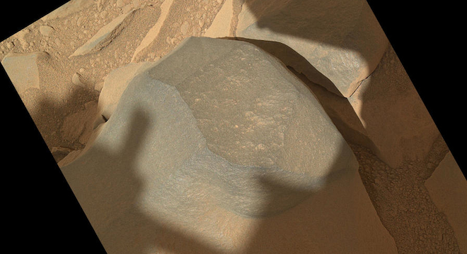
Curiosity’s inspection of the rock known as “Bathurst Inlet” produced the closest view yet of a Martian rock sample during the mission, revealing the rock is smooth, dark gray in color and contains no individually distinguishable grains, meaning if they are there, they’re smaller than 0.9 millimeter in diameter (or less than 80 microns). But the top is clearly sprinkled with the classic red Martian dust of lore.
Here’s a view of the Bathurst Inlet rock captured by the MAHLI instrument from 10.5 inches away:

Here’s a view of the rock from just 1.6 inches away:

And here’s a view of the rover’s 7-foot-long arm, on the end of which the MAHLI instrument is located, touching the rock. This view was captured by the rover’s black-and-white Navcam:

Curiosity also used its Alpha Particle X-Ray Spectrometer (APXS) instrument, another one located on the rover’s “hand” designed to irradiate rock samples to detect their chemical composition.
The rover, which is on a quarter-mile-long journey (1300 feet or 400 meters) from its landing site, has stopped along the way to inspect interesting features of the Martian landscape, including the previously mentioned Martian streambed, the “Bathurst Inlet” rock and another rock nicknamed “Jake” in honor of the late NASA rover scientist Jacob Matijevic.
NASA is seeking to drive the six-wheeled, car-sized rover to Glenelg because satellite photos taken by orbiters above Mars indicate that the area contains diverse and varied intersecting geology, giving scientists the opportunity to examine different types of Martian terrain.
The rover’s ultimate destination during its nearly two-year long mission, though, is a relatively nearby Martian mountain known as Mount Sharp, which rises 3.4 miles from the floor of Gale Crater, also where the rover plunked down on August 6 Eastern (Earth) time.


