After just over a week on the Red Planet, NASA’s Mars Curiosity Rover is gearing up to go exploring.
In a teleconference on Tuesday, NASA scientists said that the rover’s computers were successfully upgraded to an entirely new operating system, one designed for surface activities, and now NASA has begun to share new images of where Curiosity’s control crew wants to drive the rover, beginning with a short test-drive expected to occur in five or six days time.
“We’re still evaluating the capability of the rover,” said Ashwin Vasavada, the deputy project scientist for the Mars Curiosity Rover mission at NASA’s Jet Propulsion Laboratory in Pasadena, California, in the Tuesday afternoon teleconference. “It can drive something like a football field a day.”
As part of its effort to map out just where Curiosity will be going and how it will get there, NASA on Tuesday also released five new images of the rover’s immediate surroundings and its destination, including a spectacular new overhead view of the Martian terrain in its nearby vicinity captured by a NASA satellite, the Mars Reconnaissance Orbiter.

Specifically, the image, snapped by the satellite’s HiRISE high-resolution camera, shows a slice of the Red Planet’s surface extending of 980 feet due south from the rover (the rover is noted in the annotation at the top of the image), moving toward its intended target — a 3.4-mile-high Martian mountain known as Mount Sharp. The rich blue hues aren’t natural coloration, but rather a false-color added by NASA to help visualize rocks that are actually probably closer to gray in color.
Still, the image helps to show how varied the terrain becomes away from the rover — speckled with active, moving, saltating sand dunes and exposed bedrock layers, providing NASA with rich opportunities for exploration of the Martian geologic history.
“The bedrock layers are far more colorful in that vicinity,” Vasavada said.
But before NASA gets the rover to the mountain, it first wants to test drive the car-sized robot with a short forward traverse of “just a few meters” followed by a reversal and a sideways motion.
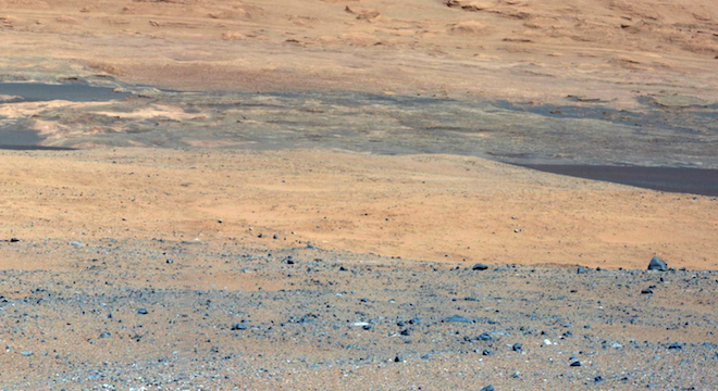
Still, the area around the rover is becoming clearer and more compelling thanks to new imagery captured by its twin mast cameras, or Mastcam, and published by NASA on Tuesday.

NASA expects to conduct the rover’s first test-drive in “less than a week,” said Mars Curiosity mission manager Michael Watkins, “probably five or six days from now,” putting the first opportunity at Sunday, August 19.
“For the most part this area has just a few amount of hazards we can’t drive across or could get permanently trapped in,” Watkins added, referring to the rover’s landing site, an area known as “Yellowknife,” or quadrant 51, which is about 15 miles away from Mount Sharp, itself located in the 96-mile-wide Gale Crater, an enormous shallow area where scientists believe liquid water may have been retained on ancient Mars.
Even though Mount Sharp is a relatively close distance from the rover — thanks to an ace landing that was only 1.5 miles off its intended target — it will take the better part of a year to get to the base of the mountain, according to NASA scientists.
That’s because the rover will stop two to three times at various points along its trek to take samples of the Martian soil and geology. Each stop will take several weeks. Plus, NASA scientists want to be cautious not to run the rover into any obstacles.
The Mars Curiosity Rover is NASA’s largest rover ever launched, a 10-foot-long, 9-foot-wide, 7-feet-tall vehicle with six wheels and a wheelbase of over nine feet, roughly as large as a Hummer H2. It can climb rocks as high as 3.3 feet without difficulty, but could have trouble with other aspects of the Martian terrain.
We “usually try to not drive over any rocks or slopes over 20 degrees or so particularly if they’re sandy,” said Vasavada.
Add to that the fact that the rover is about “100 football fields” away from the mountain and travels about the length of one football field per day, and the time of its journey, including stops, quickly adds up to nearly a year.
Vasavada said that NASA scientists had determined “at least six different routes,” for the rover to take to get to Mount Sharp, all of which looked “traversable” from satellite imagery captured by the Mars Reconnaissance Orbiter, but that some could actually be much better than others for the rover. Scientists won’t know for sure until they actually begin driving toward the area where the routes begin.
Once the Mars Curiosity Rover gets to the base of Mount Sharp, NASA scientists aim to drive it up to an elevation of “a few hundred meters,” or five or six hundred feet, Vasavada said. That’s where NASA hopes to analyze sediments of the ancient Martian geology to see whether there are any indications the planet could have been habitable — or maintaing the conditions necessary for life.
Until then, Web users can take a test-drive of their own using NASA’s free Mars Curiosity Rover surface simulator “Free Drive.”


