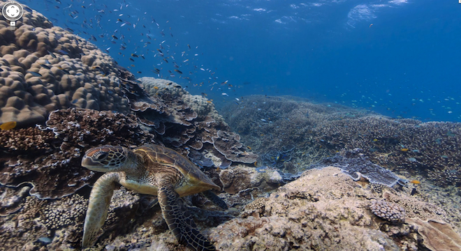
Google has gone off the deep end: On Tuesday evening, the company published on Google Maps panoramic 360-degree underwater views of six of the world’s most vibrant living coral reefs, including the Great Barrier Reef off the Australian coast.
The views, which show close-ups and zoomable shots of turtles, fish, coral polyps and other marine life, simulating the experience of actually diving and swimming through the underwater forests, may be Google’s most awe-inspiring maps imagery yet, and that’s saying something, given Google’s concerted push this year to bring Web users “Street View” style panoramas of such esoteric places as Antarctica, NASA’s Kennedy Space Center and inside the White House.
Aspiring virtual divers can see for themselves in the following video Google released promoting the new underwater imagery, which the company actually premiered Wednesday morning at the Blue Ocean Film Festival in Monterey, California:
Google is also hosing a “Google Plus Hangout” featuring a “live dive” as part of the ongoing expedition at 1:30 a.m. EDT. An older live dive Hangout can be seen here.
And here’s one of the panoramas Google and Catlin captured in their survey of the Great Barrier Reef. It shows Green sea turtles swimming off Heron Island, Australia.
Here’s another panorama in Hanauma Bay off the island of Oahu, Hawai’i:
View Larger Map
Finally, here’s a third panoramic view of polyps and coral structures found off Apo Island in the Philippines:
View Larger Map
In total, the six areas mapped so far include:
–Wilson Island, Great Barrier Reef, Australia
–Heron Island, Great Barrier Reef, Australia
–Lady Elliot Island, Great Barrier Reef, Australia
–Apo Island, Philippines
–Hanauma Bay, Oahu, Hawai’i, USA
–Molokini Crater, Maui, Hawai’i, USA
The views were captured by divers using specialized, tablet-controlled underwater cameras called the Seaview SVII, of which there are only two in the world. The SVII takes 360-degree images at a rate of one every three seconds is diver operator swims through the water at 2.5 miles per hour, according to the company that designed them and deployed the divers, Catlin Seaview Survey, which partnered with Google in the effort.
As the Catlin Seaview Survey wrote on its website about designing the SVII cameras: “The Catlin Seaview SVII camera does for the underwater, what Google’s Street View did for dry land.”
Jenifer Austin Foulkes, manager of Google’s little-known “Oceans Program” issued the following statement Wednesday in a Catlin press release about the collaboration:
“We are partnering with the Catlin Seaview Survey to make this amazing imagery available to more than one billion monthly users of Google Maps across the world. Together we want to make these special underwater locations as accessible to people as the roads and landmarks they explore in Google Maps each day,”
The Catlin Seaview Survey is a new scientific expedition funded by global insurance giant Catlin, based in Bermuda.
And for Web users eager to take more virtual dives into the deep, there’s good news: The Seaview Survey actually just began on September 16 and runs through December, with many more underwater views still to come. The scientific team plans to take a whopping 50,000 panoramic, geotagged images of the Great Barrier Reef (each one its own rotatable 360 degree image) during that time, as well as conduct a “deep reef” survey of areas scarcely visited by humans using robotic submarines and HD cameras.
Here’s Catlin’s map of the planned survey route:

Altogether, the Catlin Seaview Survey is actually the fourth such expedition financed and launched by the company, with earlier surveys documenting environmental changes in the Arctic.
And pretty pictures aside, the actual basis of the Catlin’s new Seaview Survey is conservation-minded as well, with all of the data that its divers collect about the reef ecosystems over the course of their expeditions due to be published in a Global Reef Record database managed by the Global Change Institute at The University of Queensland, Australia.
“The Global Reef Record is a game-changing scientific tool that scientists around the world will have at their fingertips,” said preeminent Queensland coral biologist Ove Hoegh-Guldberg, in a statement about the project. “They will be able to monitor change in marine environments now and in the future. Marine scientists researching any aspect of the reef will be able to study these environments from any of the surveys we conduct — Shallow Reef or Deep Reef.”
Late update: A Google spokesperson has provided TPM the following statement explaining Google’s motivations for undertaking the project, aside from wowing the Web:
Our ongoing effort to create the perfect map — one that is as comprehensive, accurate and easy to use as possible — has led Street View to evolve beyond providing imagery of just streets. This type of 360-degree, panoramic imagery is now available in 40 countries, and we’ve seen positive responses from both users who benefit from this imagery to virtually travel or preview locations before they visit in person, as well as partners like universities and ski resorts who are working with us to provide a more complete map of the world. We’re excited about the many possibilities we have yet to explore, and to bring more useful and beautiful imagery to Google Maps users around the globe.
Sure sounds like Google Space may be on the deck.


